
From Mega Dams to Trans-Himalayan Rail: China’s Infrastructure Push Meets a Himalayan Disaster
SHIMLA/NEWDELHI: The devastation caused by the Bhote Koshi flash floods has brought a much larger question into focus: how safe is the Himalayan belt as China pushes ahead with massive hydropower, transport and connectivity projects across the Tibetan plateau and towards Nepal?
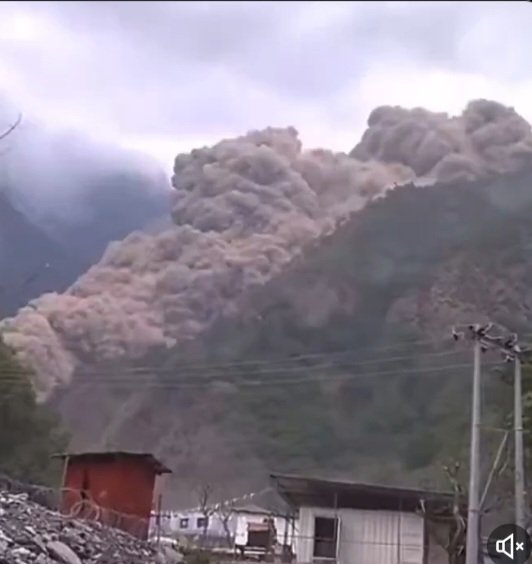
The immediate disaster was linked by scientists and authorities to a catastrophic ice-and-rock avalanche and glacier collapse, which sent an enormous torrent of water, mud and debris down the Bhote Koshi system. Reuters reported that the debris flow travelled more than 20 km and devastated infrastructure on both sides of the border.
The destruction has included roads, bridges, settlements and hydropower installations.
That has intensified scrutiny of the wider infrastructure landscape in one of the world's most geologically fragile regions.
China has been developing a vast network of hydropower, roads and railways across Tibet, including projects linked to the Yarlung Tsangpo, which becomes the Brahmaputra after entering India.
At the same time, Beijing is extending its Tibetan railway network southwards. China has been working on extending the railway from Shigatse towards Kerung, near the Nepal border, with the proposed Kerung-Kathmandu railway designed to create a trans-Himalayan rail connection.
Nepal's feasibility study for the 72-km Nepal section has examined tunnels, bridges, geological conditions and construction challenges across Kathmandu, Nuwakot and Rasuwa.
The scale of the proposed railway itself underlines the engineering challenge.
Nepal's preliminary assessment found that approximately 98.5% of the proposed railway could consist of bridges or tunnels, reflecting the extreme Himalayan terrain and seismic conditions. The study also identified active faults, rock-burst risks, unstable slopes, water erosion and other geological hazards.
The railway is only one part of a much larger Chinese connectivity push.
The strategic significance of the proposed route extends beyond passengers. The railway is expected to function largely as a freight corridor, potentially linking Nepal more directly with China's Tibetan transport network and wider South Asian markets.
That makes the current catastrophe particularly significant.
The flood destroyed or damaged infrastructure along precisely the kind of Himalayan corridor where roads, hydropower installations and cross-border connectivity projects are expanding.
The question is therefore no longer simply whether the Himalayas can physically accommodate ever-larger infrastructure projects.
It is whether climate risk, seismic risk, glacier instability, landslide hazards and downstream consequences are being incorporated into the design, location and operation of those projects — and whether countries downstream receive adequate real-time warning when an extreme event develops upstream.
The present disaster offers a stark warning.
On Friday, a newly formed barrier lake near the China-Nepal border began overflowing. Authorities feared that another sudden release could trigger a secondary disaster, forcing rescue teams to temporarily halt operations and ordering communities downstream to move to higher ground.
The Himalayan infrastructure race is therefore entering a new test.
Mega hydropower projects, highways and railways may promise connectivity and energy security.
But in Himalayan region where glaciers can collapse, mountains can move and rivers can rise violently within minutes, the real measure of infrastructure cannot be its size alone.
It must also be its resilience — and the quality of the warning system protecting people downstream.