
SHIMLA/LEH/DEHRADUN/ITANAGAR: Himalayas placed in new highest-risk seismic zone-VI, scientists call it the strongest warning yet
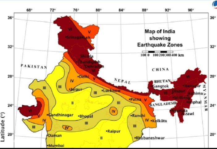
India has made a major update in its earthquake-safety map by introducing a new and highest hazard category called seismic zone-VI. The Bureau of Indian Standards (BIS) has placed the entire Himalayan belt in this top-risk zone under the revised Earthquake Design Code IS 1893:2025.
With this change, all Himalayan states — Ladakh, Jammu and Kashmir, Himachal Pradesh, Uttarakhand, Sikkim, Arunachal Pradesh and the entire Northeast — are now officially marked as extremely vulnerable to high-intensity earthquakes.
Officials involved in drafting the code say the previous map did not fully represent the real threat. According to a senior BIS expert, the earlier classification often confused planners and builders.
He said the new zone-VI is based on modern scientific assessment and gives a clearer picture of the danger in the mountains.
Scientists at the Wadia Institute of Himalayan Geology (WIHG), Dehradun, have welcomed the step.
Dr. Vineet Gahalaut, Director of WIHG, said the entire Himalayan arc sits on locked fault systems capable of producing very large earthquakes. “Many sections of the central Himalayas have not ruptured for centuries. The stress build-up is high, and the risk is real. Bringing the whole region under zone-VI makes scientific sense,” he said.
The National Centre for Seismology (NCS), the government’s main earthquake monitoring agency, has also supported the new classification. An NCS scientist said ground shaking in the Himalayan belt is far stronger than what many old building designs assumed, and the new category finally matches the scientific reality.
IMD officials added that this move strengthens the need for earthquake early warning systems and more dense monitoring networks across the region.
The new zone-VI marking will lead to stricter construction rules for all new buildings. Old structures, especially hospitals, schools, bridges and government offices in hill towns such as Shimla, Dharamshala, Kullu, Dehradun, Gangtok and Itanagar, will need safety audits and retrofitting. State governments must also revise their building bylaws and disaster management plans.
Experts say the message is clear: the Himalayan region is at extreme seismic risk. Strong rules, safer construction and retrofitting of old buildings are the only ways to reduce casualties when a major quake strikes.
#Himalaya #Earthquake #ZoneVI #DisasterPreparedness #Himbumail